To travel in Canada is predominantly—oppressively—to follow straight lines. From St. John’s to Vancouver, Canadians proceed east to west and back again, sometimes pausing in an airport lounge before taking a right angle north or travelling due south if the Arctic or Subarctic are the places left behind. Then back we go the way we came. What is the alternative? Canadians wanting to learn their country—almost inevitably having to follow and then return along the constraining, linear route of the Canadian Pacific Railway—are victims of a monotonous, dispiriting tedium.
The one-dimensional trajectory of our core transportation network means our journeys are inherently ones of disappointment. Canadian travellers do everything we advise lovers parting ways not to do: they make U-turns; they go back; they revisit points already known because the road less travelled—well, it doesn’t exist. The psychogeography of Canadian travel is brutal.
Wander America, by contrast, and the map is one of myriad and easy possibilities. Mark Twain went east and west, but also journeyed up and down the grand fluvial axis of the Mississippi. Thomas Wolfe’s Eugene Gant took the train from the South to New England in one of the most exhilarating journeys in literature. The meandering of Jack Kerouac’s characters in On the Road is a celebration of geographical and life choice.
That possibility of the unknown—of the open road that narratologists will tell you is the source of one of a handful of archetypal stories (the stranger arriving in town on that road is another)—ended with our country’s foundation. It was killed in 1885 with the pounding of the “last spike” and the completion of a railway that transformed Canada into an orderly, pragmatic project. The bulk of the Trans-Canada Highway that is the legacy of the CPR is an equally inadequate route, running as it does along the same thin and unrepresentative slice of the country hard by the United States border, short-changing Canadians of national experience and identity.
If Canadians could navigate the further reaches, would they not be rendered intrepid again? They could lose themselves in the rapturous state that came naturally to the territory’s first cartographers and the Indigenous map-makers who preceded them. Journeys were mysterious then.
Severed from the great expanses that shape us—take it on faith, the North defines us (though how many of us outsiders have actually visited?)—we’ve been reduced to idle spectators of the American frontier ever since. (“I like to ride my bike to the border and stare at America,” says sixteen-year-old Nomi Nickel, aching to exit the hell of her Mennonite hometown in Miriam Toews’s novel, A Complicated Kindness. “Nomi from Nowhere says hello.”)
From Cape Spear to Boundary Peak 187, from Lake Erie to Ellesmere Island, our conviction is that life is something happening elsewhere. How debilitating this lack has been to the Canadian spirit! That “elsewhere” could be, should be, a riveting us, a nation gifted with regional differences and idiosyncrasies that our dearth of access prevents us from knowing—and owning.
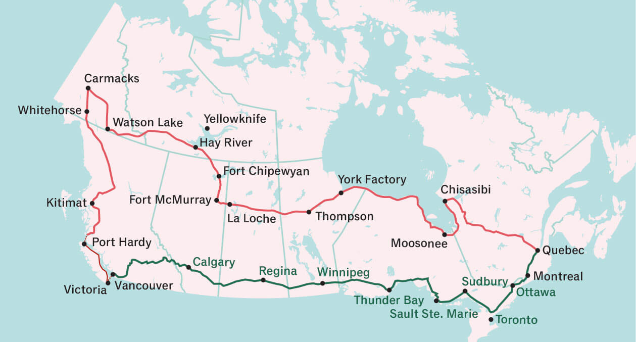
What if it were possible to transcend the tyranny of our country’s inhibiting travel grid? What if Canadians could voyage along a Great Circular Road encompassing the crazy breadth and expanse of our enormous, untravelled middle? What if it were possible to leave Montreal (arbitrary, I know, but the city was home), on four wheels or two, and travel via Quebec City, say, to Chisasibi, on the east side of James Bay, across to Moosonee on the other, and continue upward to the shores of Hudson Bay—that body of water so integral to the history and foundation of Canada—to York Factory, Manitoba, and then Thompson? Our route would proceed to La Loche, Saskatchewan, through Fort McMurray and Fort Chipewyan, Alberta. Why, from there it’s only a short taiga skip and a jump to Hay River, Northwest Territories, and Watson Lake and Carmacks, Yukon, and then a descent through the Pacific Northwest into Kitimat, Port Hardy, Victoria, and Vancouver, British Columbia. Then—it’s inevitable (the highway is but a fragment of a greater existential journey now)—we’re back along the Trans-Canada and home.
A Great Circular Road would allow Canadians to learn the country—and to do so without ever ceasing to go forward. Advance and retreat would no longer be the insidious condition of spiritually defeating Canadian peregrination. How binding the new road would be! We’d be educated through our better acquaintance with one another and—travelling the circle rather than the US-hugging straight line of Canada—be offered the thrill of the constantly new.
Such is the territory’s indomitable nature that innumerable communities would remain, as they are now, beyond. And yet they would be closer, no longer in the attic of most Canadians’ minds but on the manageable fringes—and this at a time when Arctic incursions by Americans, Danes, and Russians make plain the necessity of more linkage with ourselves.
Much of the Great Circular Road already exists. Its finished loop—a qualitatively different idea of Canadian infinity than is offered by the open roof (now closed) of Canada’s North—would connect Kitimat to a resurgent Fort McMurray more directly than through Bruderheim, the proposed route of the scrapped Northern Gateway pipeline. A straighter, all-season course from Fort McMurray to La Loche would cut an astounding 800 kilometres from today’s absurd horseshoe journey through Cold Lake. And from there to Thompson are the luxury and the savings of roads in place.
But even then, we’d be only halfway. So bring on the engineers, heroes through the late twentieth century until their undoing by radical environmentalism and political complacency. From Thompson to the western shore of Hudson Bay, there are about 360 kilometres of road that our new nation-building ambition demands we construct alongside a portion of the York Factory Express, former river-bound path of fur traders, because we respect the routes of our predecessors if we’re wise. From there to Attawapiskat (linked by seasonal winter roads to Kashechewan, Moosonee, and Fort Albany) there are more than a thousand kilometres of water and muskeg to be traversed, and then the homestretch of our connection to Kapuskasing and an extant road to Saguenay. It’s a breeze, thereafter.
The gift of space is Canada’s blessing but also its curse. It provides us with the means to be ourselves, but also room to never have to engage. Our geography may be wondrous, but it is the source of our anomie. Let a Great Circular Road end it. Let no place continue to be far.