In the early morning of August 8, 2007, at the cusp of New York’s epic rush hour, the grey sky over Gotham burst open in a fearsome downpour, the third major storm in seven months. Within a few hours, the flooding was so severe that the Metropolitan Transportation Authority (mta) cancelled all Metro-North trains, the city’s link to suburbs across the state and into Connecticut. In addition, all twenty-four of the mta’s subway lines were either delayed, or suspended for up to eight hours. Meanwhile, the storm whipped up an exceedingly rare category 2 tornado that slammed into the southwest shoreline of Brooklyn. With winds reaching 217 kilometres an hour, the twister shredded roofs, wrapped street signs around their poles, and uprooted trees. When the so-called 8/8 deluge subsided, it had contributed to one death, caused untold millions of dollars of damage, and disrupted the commutes of 2.5 million crabby New Yorkers.
Elizabeth Yeampierre was one of the lucky ones, given that the tornado hit a mere thirty blocks from her office in a narrow row house in the waterfront Brooklyn neighbourhood of Sunset Park. An energetic civil rights lawyer with unruly black hair, Yeampierre heads uprose, an ngo founded in the mid-1960s to support Sunset Park’s disenfranchised Puerto Rican community. Lately, uprose has focused on engaging this diverse blue-collar precinct in environmental issues, spearheading campaigns to block the construction of a shoreline power plant and push for more green space on the water. Yeampierre added climate change to her agenda last summer, but it’s a tough sell in an area where many residents hold down two or three jobs just to get by. “People go through their lives passively, not thinking about what all this means,” she observes. The 8/8 deluge, however, left little doubt of Sunset Park’s vulnerability to the vicious storms experts have associated with global warming. “You know,” she says, “that was a wake-up call.”
Indeed, storms like 8/8 are only the tip of the proverbial iceberg. As rising global temperatures melt polar ice sheets, sea levels rise as well. At the same time, many scientists believe warmer oceans are increasing the frequency and violence of hurricanes. When combined with high tides and elevated sea levels, these conditions can produce fearsome walls of water that pound shorelines. In coming years, this three-pronged threat could cripple coastal regions that haven’t protected themselves against storm surges and flash floods.
In late 2006, Sir Nicholas Stern, an adviser to the British government, released a study documenting the accruing economic impact of climate change. The most comprehensive of several such studies, the Stern review warned that by the 2080s rising sea levels could be dislocating tens of millions of urbanites annually in Asia, North America, Europe, and Australia. Besides the incalculable human toll, vital infrastructure—subways, power plants, ports, airports, water treatment facilities—will become ever more vulnerable to flooding. As Stern noted, Hurricane Katrina caused more than 1,300 deaths, displaced a million Americans, and inflicted $125 billion (US) in damage, only 40 percent of which was insured.
“New Orleans weighs heavily on our minds,” Yeampierre says. And no wonder. New York is surrounded by water: the Atlantic, Long Island Sound, and the Hudson, Harlem, and East rivers. The city has some 2,000 bridges and tunnels, and 10 percent of its land mass, including much of Lower Manhattan, the city’s three airports, and the vast docklands in Jersey City, is less than three metres above sea level—for now, that is.
Of particular concern is the impact on infrastructure situated within the flood zone, including fourteen water and sewage treatment plants. Hundreds of combined sewer outflows embedded in seawalls line the city’s extensive shoreline, and if water levels spike, these pipes could be abruptly inundated, resulting in a massive flow of contaminated backwash into countless basements.
New York’s transit infrastructure is even more at risk, because so much of it is already below sea level. Even on a sunny day, the mta pumps more than 49 million litres of water out of the subways (enough to fill nineteen Olympic pools), but a panel of experts recruited by the mta after 8/8 determined that those mechanical systems had been overwhelmed—and not for the first time. They recommended elevating the subway’s sidewalk grates, building step-up curbs at station entrances, and installing more pumps. But, as they also pointedly warned, “Flooding cannot be solved by narrow engineering solutions based solely on past experience.”
Malcolm Bowman, an oceanographer at the State University of New York’s Stony Brook campus on Long Island, isn’t interested in “narrow engineering solutions.” A native New Zealander with the white beard and twinkling eyes of an off-season Santa, Bowman and collaborator Douglas Hill have spent seven years shopping around a proposal to build enormous retractable storm surge barriers in three locations around New York, including one straddling the Verrazano Narrows, and another at Throgs Neck, where Long Island Sound meets the East River. Such barriers, rising fifteen metres above sea level, would effectively wall off New York Harbor if a major hurricane sent tsunami-like waves toward the city. “This would be one of the biggest engineering projects in the history of the United States,” Bowman states.
The walls of Bowman’s office at Stony Brook, where he’s taught since 1971, sport an eclectic assortment of maritime memorabilia, including a poster-sized reproduction of the New York Times from September 13, 1960, the day after Hurricane Donna slammed into the city; the photograph shows soggy New Yorkers wading through waist-high flood water. The one-time submarine spotter, who went on to earn his doctorate in engineering physics from the University of Saskatchewan, has focused his research on the US eastern seaboard, in part documenting the trajectory of storm surges heading toward New York. In recent years, this work has prompted a side interest in famous storms and their political legacies.
In 1953, for example, a mid-winter Atlantic storm swooped over Scotland and roared southeast into the North Sea. Intense winds whipped up waves that rose to more than three metres above the mean high tide, producing devastating floods in England and the Netherlands. The roiling water reached all the way up the Thames estuary into central London.
While London had been building up the embankments along the Thames since the late nineteenth century, the 1953 storm galvanized Westminster to ensure that Britain’s first city was adequately protected. It took thirty years to build the Thames Flood Barrier, a 520-metre safety valve located about five kilometres east of the Isle of Dogs. Clearly visible in satellite photographs, the barrier consists of nine conch-shaped piers, between which swivel twenty-metre-high, steel-plated flood-gates. Engineered to withstand a storm that would only be likely to occur once in 1,000 years, it has been closed more than 100 times.
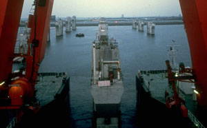
The Dutch, who have spent centuries building extensive dikes and canal networks to protect a country carved out from the sea, responded to the 1953 disaster with similar gravitas. Between the 1960s and the 1980s, the government built numerous protective barriers in strategic locations, including an extraordinary three-kilometre-long sluice gate across the Eastern Scheldt, a flood-prone river delta in Zeeland, south of Rotterdam. The Dutch engineer their barriers to withstand a 10,000-year storm. “They don’t mess around,” says Bowman. “It’s a question of national security.”
New York, for its part, sits on a tropical hurricane path and has been repeatedly slammed by major storms over the past century, including the 1938 Long Island Express. But the city has done surprisingly little to protect itself, besides building seawalls around LaGuardia Airport, and producing a new emergency evacuation plan in the aftermath of 8/8. Why? Bowman tells a story about meeting senior engineers for the Port Authority of New York and New Jersey, the agency that manages the city’s airports, tunnels, bridges, and ports, and whose assets are highly vulnerable because they’re at or below sea level. “They were all very polite and interested in what we had to say about sea level rise and storm surge barriers,” he recounted. “But [they said] it’s long term and we have more immediate things to worry about.” The meeting took place at the World Trade Center, a week before 9/11.
In light of subsequent events—imagined (as in The Day After Tomorrow, a 2004 blockbuster that portrayed the cataclysmic submergence of Manhattan) and then real (New Orleans)—Bowman’s proposal has begun to attract more serious scrutiny from the climate change experts and media. Even Mayor Michael Bloomberg’s long-term climate change plan for the city, released in April 2007, openly acknowledges the risk posed by long-term sea level rise. But there is scant official enthusiasm for a barrier that would be both monumental and monumentally expensive.
Klaus Jacob, a Columbia University geophysicist who worked on the 8/8 report for the mta, shares Bowman’s unease about the city’s blithe resistance to the lessons of storms past and the threat of future flooding. He says the kind of infrastructure now being planned—e.g., a third tunnel into Penn Station—is based on maps created in the 1970s that show the theoretical upper extent of water infiltration in the event of a 100-year storm. “It’s outright inexcusable,” Jacob says, peering over his heavy black glasses. Yet he does not support the idea of a barrier. “It’s just not sustainable—not financially, nor from an engineering point of view.”
The Verrazano Narrows barrier, for example, would have to have a base as long as a football field anchored to the bottom of the harbour, which is 100 metres deep. (By contrast, the Thames Barrier sits on a riverbed that’s only six metres below the surface.) And if New York asks the federal government for funds to finance a series of storm surge barriers, other vulnerable cities—Boston, Miami, San Francisco—will demand equal treatment. Combined with necessary maintenance expenses, to avoid a New Orleans–type disaster, the costs are just too high.
Perhaps getting to the heart of the mta advisory panel’s ambiguous warning, Jacob adds that engineered solutions “freeze in the risk.” In other words, given the alarming but ultimately unpredictable acceleration of climate change, there’s no telling how long a given barrier would afford the necessary protection (even if it were properly maintained), and therefore such structures create a false sense of security and a heightened risk for those who depend on them.
In Jacob’s view, coastal cities won’t win the long war against an angry climate. He says the Netherlands, which relies heavily on engineered solutions, has adopted a pragmatic and flexible approach tailored to an uncertain future. Of course, the government closely regulates its seawalls and storm surge barriers, all of which are built to withstand storms of almost unimaginable severity. But in recent years, Jacob says, Dutch authorities have admitted that these protections have limitations: as the seas rise, it’s neither possible nor cost effective to continue building them up ad infinitum.
Instead, Dutch architects are now experimenting with dwellings moored to posts and designed to float on concrete pontoons, as a way of responding to the threat of flooding. Meanwhile, the government has opted to allow controlled “overtopping,” permitting the sea to breach existing shoreline dikes (covered in reinforced grass, to prevent erosion) and seep into nature reserves beyond. The aim of such approaches is to accommodate flooding, to work with rather than against climate change.
New York’s situation is obviously different, but Jacob nonetheless argues that his city must “put land use planning in the context of climate change.” In other words, when New York considers waterfront development or the deployment of subsurface infrastructure, it should anticipate where flood zones could extend decades or centuries hence. The city’s population will likely grow by a million within the next twenty-five years, and, Jacob says ominously, “When we try to look for places to put those million people, we must aim for areas we won’t have to give up soon.”
When Malcolm Bowman presents his scheme for barriers for New York Harbor, he uses a PowerPoint presentation that begins with a cheeky question:
Q: When do you plan for a flood?
A: Too late.
From his study of the history of flood barriers, Bowman knows that it takes a disaster, plus years of planning, to marshal the political will and wherewithal to get such projects off the drawing board. Katrina’s legacy is being felt far beyond the confines of New Orleans, as coastal cities around the world begin to look closely at their own long-term exposure. A handful have recognized rising seas as a serious threat to national security, and are protecting themselves with barriers and other flood protection infrastructure—e.g., retractable barriers around the Venice lagoon, in Italy, and St. Petersburg, Russia, both of which are taking years to build; and the honeycomb of giant stormwater holding tanks beneath Tokyo, which sits directly in the path of tsunamis and cyclones.
Such huge projects are the latest chapters in the long-running story of man’s compulsion to engineer his way past immense natural impediments. But if Jacob is right, this impulse may no longer be useful in the face of human- engineered climate change. Indeed, coastal cities like New York may have arrived at a pivotal moment, where they must begin to reverse the tide of relentless urban expansion and beat a strategic retreat from the water’s edge.
With or without barriers or other such mechanisms, one point is certain: failure to act is no longer an option. Jacob cites Alexandria, the cultural hub of the ancient world. Situated on the Nile Delta, the original city was gradually overwhelmed by silt. “By the time Napoleon got there,” Jacob says, “it was a village.”


